
Last updated: 2026-10-19
Design a Detroit Map Poster
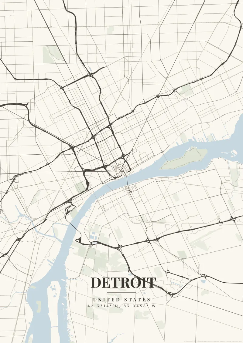
Build Your Detroit Map ArtOrder this print
Free to design · Printed posters from $24.99, shipping included to 20 countries
Five massive diagonal avenues, Michigan, Woodward, Gratiot, Grand River, Jefferson, explode outward from Campus Martius like cracks in glass. Augustus Woodward drew them in 1805, stealing L'Enfant's Washington playbook, and they still slash violently through the otherwise rigid Cartesian grid, producing the jagged triangular blocks and bizarre six-way intersections that make Detroit's map impossible to mistake for anywhere else. The Detroit River runs wide and dark along the southern edge, connecting Lake St. Clair to Lake Erie, and here the map delivers its most disorienting surprise: Canada sits directly south, Windsor's skyline staring back across the water.
Detroit — the city's layout
A custom map poster of Detroit, United States turns a meaningful location into personalized wall art — completely free with MapPoster.
This is a city that built the 20th century and then watched it leave. The scars are on the map, vast empty blocks on the east side where entire neighborhoods vanished, but so is the comeback. Corktown, Detroit's oldest neighborhood, now throbs with restaurants and the new Ford Motor campus. Eastern Market's six massive sheds anchor Saturday mornings. Belle Isle, a 982-acre Frederick Olmsted island park floating in the Detroit River, appears on the map as a green jewel completely surrounded by current. Motown burgundy, raw industrial steel, or bold Lions Honolulu blue honor a city that has stared down collapse and refused to quit.
Printed and shipped to your door
Design your Detroit map poster for free, then order it printed from the same editor. Posters print at 300 DPI on 170 gsm silk paper (A4 on 350 gsm card), and tracked shipping to 20 countries is included in every price. Each print is made to order within 3 business days, then usually arrives 3 to 6 business days after it ships (longer to Canada, Australia, Norway, New Zealand, Japan, Brazil and Mexico).
| Size | Dimensions | Poster |
|---|---|---|
| A4 | 8.3 × 11.7″ | $24.99 |
| 12 × 18″ | 30 × 46 cm | $34.99 |
| 16 × 20″ | 41 × 51 cm | $39.99 |
| 18 × 24″ | 46 × 61 cm | $44.99 |
| 12 × 12″ | 30 × 30 cm | $29.99 |
| 20 × 20″ | 50 × 50 cm | $44.99 |
Also framed (black, white or oak) from $79.99, on canvas from $69.99. Prices in USD, shipping included; checkout switches to EUR or GBP based on where you are. A print that arrives damaged is reprinted or refunded for free.
Frequently Asked Questions
Can I order a printed Detroit map poster?
Yes. Design your Detroit poster, then order it from the editor as a poster from $24.99, framed (black, white or oak) from $79.99, on canvas from $69.99. Prints are made at 300 DPI, tracked shipping to 20 countries is included in the price, and each print is made to order within 3 business days, then usually arrives 3 to 6 business days after it ships (longer to Canada, Australia, Norway, New Zealand, Japan, Brazil and Mexico).
What themes are available?
MapPoster has 50+ themes: 50+ artistic vector styles, including classic city maps with street names (Minimal White, Midnight Dark, Modern Voyager), plus OpenStreetMap and satellite map tiles. Artistic themes render every road and waterway in custom color palettes — from moody dark tones to bright pastels.
Can I customize the colors and style of my Detroit poster?
Yes. Pick from 50+ themes, then adjust the color palette, text overlay, fonts, and layout. You can add a title, subtitle, date, and GPS coordinates for Detroit. Everything is adjustable in the editor before you download.
What file formats can I download?
Standard downloads are PNG at 1080p. The $6.99 high-resolution export unlocks up to 7200px in PNG, JPEG, WebP, PDF, and SVG — all at 300 DPI for print.